Beckman's Gasthof

A summary of the Beckman's explorations in our new Tiffin Phaeton.

Sunday, July 23, 2006

Ontanogan, Michigan


Great wildlife was seen in Copper River Falls State Campground. A porcupine walked right past our campground, we saw and heard Loons on Loon Lake, and had lots of deer walk right past our campsite. There are definitely advantages to staying in state parks off the beaten pathway. The hiking is much better also. But it was time to move on. So we drove all of 90 miles across the Wisconsin border into Michigan.

We are camped at the mouth of the Ontonagon River in Ontonagon, Mi. Ontonagon is a thriving metropolis of 1,700 people. It’s located on the south shore of Lake Superior. This community is known for its great fishing. Lake Superior has nice sandy beaches (?) or shoreline that people use for swimming and sun bathing. Lake Superior is huge-hundreds of miles across. It seems strange to be looking at such a large body of water and it’s fresh water. There are no crowded beaches here.

We took a drive about 20 minutes to the west to tour Porcupine Mountains Wilderness State Park. It’s a gorgeous old hemlock forest that runs right down to Lake Superior. This area was known for its copper mines but they are no longer worked. The only inhabitants in the mines now are bats.

We sampled the local fish fry. It was very good. This morning we walked into town and had breakfast at the local bakery. Ontonagen has 3 restaurants, one of which is the bakery, one grocery store, and one flashing light (not a stop light). There are a lot of Finns in this area and I was happy to see Pannu Kakkua on the menu. It was okay but not nearly as good as yours Susie M. (For the non Finns in the group, they called it a Finnish pancake, but it’s really a cooked custard.)

Thank goodness the weather has taken a turn for the better. It’s been in the 70’s the last few days and we even had to use blankets while sleeping last night. Today, Sunday, we are even getting a little rain. Now if the rest of the country could only cool down.

.

Friday, July 21, 2006

Copper Falls State Park, Wisconsin


We were up early on Wednesday the 19th, trying to beat a storm front that was approaching from the west. We beat a hasty retreat to the east, staying in front of the rain. Since we were planning on staying at Wisconsin state park next (no restaurants), Pris hit the big food store before leaving Duluth. She came out with all sorts of wursts, since this country has many German emigrants.

We are still following US 2 east, and Wisconsin is very narrow at the top of the state. The state park we are staying at is no more than about 25 miles from the Michigan border. That is the upper peninsula of Michigan, or UP as the natives say.

The park is beautiful. Most of the sites are secluded in woods and there is Loon Lake about 1 mile from our site. The lake has a nice sandy beach and no weeds.

Thursday we took a hike around the park on beautifully maintained trails. There are a number of waterfalls on the rivers, although small in scale. We worked up a sweat doing this, so it was to the lake for a swim in the afternoon. Water temperature was in the sixties and very refreshing.

Duluth, Minnesota


We left Bemidji on Monday the 17th, heading east to Duluth. The campground we selected is west of the town, actually in Hermantown. I wonder if that is where Danny Herman comes from. Don’t think so! We got a campsite on the very back side, overlooking a large pond and an open field. Late in the afternoon a large flock of Canadian Geese descended on the pond, like dive bombers. Pris spent the night following their progress, with the older males protecting the flock when they went ashore.

Duluth marked 3000 miles from LA and the last oil change on the RV, so I scheduled that in downtown. I was lucky to get in on an hours notice. Considering that it is about 2400 miles as the crow flies coast to coast, it’s hard to believe we put 3000 miles on the RV and have just gotten to the Great Lakes.

Tuesday we took a drive in the CRV up the north coast of Lake Superior, heading northeast out of Duluth. Most of the coast is a stony bluff, up to almost 1000ft above the lakes surface. Very beautiful! This is iron ore country and we came across some of those huge ship loading docks. None of them had ships in them, so it was hard to judge their size. They appear huge. Our trip terminated at the most popular stop on the coast, Betty’s Pies.

The weather is cooling off, with highs in the mid 80s in the day and lows in the low 60s. It’s nice to enjoy sleeping without air conditioning.

Sunday, July 16, 2006

Bemidji, Minnesota

So we were up early Thursday to get the RV into the shop and went to have a long breakfast. The RV was ready to go in just over an hour. We loaded up our groceries and hooked up the CRV just before a thunderstorm hit the area. We got back on US 2 heading east and crossed into Minnesota. We scheduled a short day due to the windshield replacement, so stopped in the quaint town of Bemidji. It is the home of Paul Bunyan and his blue ox, Babe. It is also the hometown of Annie Malen, a relative of ours.

The town is situated on a large lake of the same name. We stayed in a small campground just outside of town, near a Wal Mart store. It is becoming our favorite store, since we know we can get anything there.

My string of bad luck continued with my back going out on me Friday morning and the weather continuing to get warmer. The only thing I can do for my back when this happens is to rest it, alternate cold and hot packs and walk as much as possible. After three days, I am almost back to normal.

The weather is the hottest year on record for the state of Minnesota! We are in northern Minnesota and the temperatures were near 100 Saturday. It is projected to cool somewhat over the next few days.

Minot & Great Forks, North Dakota

After leaving Teddy Roosevelt NP, we headed north to pick up highway US 2 at Minot. We stayed the night just outside of Minot and decided to treat ourselves to dinner. We found a great little restaurant, 10 Main Street. Look it up if you come to town. Pris had roasted Elk loin and I had a Bison rib eye steak. Both were out of this world.

Wednesday we headed east on US 2. The road crews were putting oil and gravel on the road for about 30 miles. Yes, you guessed it, our windshield got hit by gravel two miles from the end of the paving. It put a chip in the windshield that promptly grew into a 3 foot crack. Pris called our emergency road service, told them the situation and got a referral to an auto glass store in Grand Forks. That is where we had intended to stay anyway. We took the RV by the store on Wednesday afternoon and made arrangements to have a replacement installed first thing Thursday morning. We were lucky that they had a replacement in stock.

For the last week the temperatures have been going up. Wednesday it got to about 95. This drove us into the air conditioning, not what we had intended. I remember the movie “Fargo” and the driving snowstorm scenes. Great Forks is 100miles north of Fargo, why can’t we have some of that cold now!

Tuesday, July 11, 2006

Teddy Roosevelt National Park, North Dakota


Having studied the Little Bighorn thoroughly, it was time to move on. The next leg in our journey is to get to our friends the Janaks by the end of July. So it is north and east from southeast Montana. We left Saturday the 8th and headed up I 94. It followed the Yellowstone River, which is very impressive. It is nice rolling hills, with lots of farms and beef herds.

Saturday night was spent in Glendive Montana, not much to talk about. We did meet the Pohlmans at the same campground, Lazy Daze owners from Virginia who also attended the Cheyenne Caravan. They also were aiming for our next camp, the Teddy Roosevelt National Park in North Dakota.

We arrived at the park early Sunday afternoon. Since it is first come, first served and well off the beaten path, it was only 10% full (in July no less). So we got a great site in the trees, with great shade. The Pohlmans pulled in about 5 pm, after touring the park in their LD.

A funny thing happened at the park visitor center. Since I finished Ken Atkin’s Custer book, I was looking for something to read. There was a good selection of Lewis & Clark books, since this is the route they used. I selected one and bought it. At the counter, there was one of the national park stamps for marking parks attendance. I asked the ranger at the counter if I could use the stamp in my book, to show it to a friend of mine. He had most of the 350 + stamps. The ranger said I bet I know your friend’s name, Fred Koegler. Wow, you’re right, how do you know that? Turns out that he knows Fred from a ranger’s organization. It’s a small world.

We liked this place so much we decided to stay a second night and use it as a cleaning day. We had a great day; the sky is the bluest blue and the breezes light. We went for a walk after breakfast and decided to go down to the river here, the Little Missouri. As we approached the river, we heard what sounded like very loud snoring. Weird. The river here is about 10feet below the land level, due to erosion. As we approached the river, we looked over the bank to the river. Ten feet down was a buffalo! Snorting like hell. Well no problem, he is ten feet down. He scampered up that cliff faster than I can say run like crazy! This bull was taller at his back hump than me. And he was bigger than our CRV. He scattered the campers quickly, ambling across the campground.

Monday turned out to be the hottest day on our journey. It peaked at 96, with medium humidity. Our problem was that generator use is restricted to 8PM. It was 95 at 8, so we were hot last night.

The pictures are of the camp and the Little Missouri River, which runs next to our camp.

Friday, July 07, 2006

The Little Bighorn River, Montana


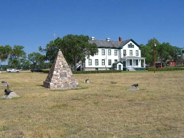
Well, I finally made it to see for myself. And Custer is dead! The national monument is well done, informative and interesting. Of course they put the positive spin on most things. Like pointing out his graduating from West Point, but failing to point out he finished last in his class. Like pointing out his rapid rise to general in the civil war, but failing to point out the only maneuver he used was to charge his enemy, without understanding their strength. Like pointing out Custer was interested in many things, but failing to mention he was not intelligent or a good student. He did like to fight, thought he was invincible and was lucky to a point.

Custer set the stage for his massacre by dividing up his forces. This was done with the full knowledge of the size of the enemy camp, which was scouted by Custer’s Crow scouts. The Sioux, Cheyenne and Arapahoe gathering was one of the largest meetings of the Plains Indians ever. About 8000 people total and 1500 to 2000 warriors were in camp that day. They were camped in the Little Bighorn valley, just west of the river which runs north-south here. Custer started out with 600 + Cavalry. When he got close to the encampment, he divided his forces into four groups. He commanded the largest group, a little over 200. He sent the Maj. Reno group to attack the village from the south, up the Little Bighorn River. Capt Benteen was sent further south and west to look for Indians trying to escape! Custer led his group around the ridge to the north and east of the camp. Custer saw Reno’s charge and rebuff by about 1000 warriors from this ridge. Reno was pushed across the river and made the high ground of the ridge with about 40 men killed. These warriors continued to attack Reno’s group until they became aware of Custer’s group, at which time they left to attack him.

Custer split his group in two, with Capt Keogh staying on the ridge and Custer going down a draw to the river, opposite the camp. That is when the Indians became aware of Custer’s group and sent word to the warriors attacking Reno to come back. The first major Indian attack hit the Capt Keogh group on the ridge. The fierce chief Gall attacked and overran this position quickly. Custer tried to get back to Keogh, but didn’t get there in time. He stopped on what is now known as Custer Hill about ½ mile away. The remaining men from the Keogh group tried to make it to Custer Hill, but almost all of them were killed going that ½ mile. About the time Gall was overrunning Keogh’s position, Crazy Horse lead a major attack up the draw that Custer had gone down and retreated up again. The remaining 100+ men under Custer didn’t last long with two attacks coming from north and south. Altogether, 210 men died on that ridge on the afternoon of June 25, 1876.

While Custer was occupying the warriors, Benteen’s group and the supply train arrived at Reno’s position on the ridge. This is about 5 miles south of Custer Hill. With this force of 350+ men and supplies, Reno was able to hold off the warriors when they returned late in the afternoon after defeating Custer. They continued to hold their ground until the Sioux camp broke up and dispersed the next day, June 26. This was caused by another army group coming up the Little Bighorn River from the north. This army relieved the Reno-Benteen group.

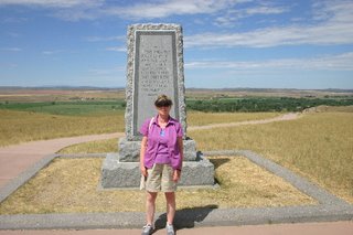
The photo with Priscilla is taken from the Reno defensive position, looking west, down on the Little Bighorn River and valley. The trees mark the river and the Sioux camp would have filled the valley on the other side of the river.

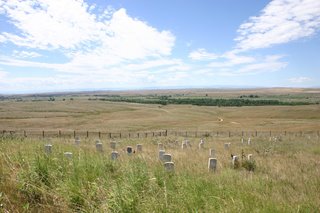
The other photo is taken from Custer Hill, looking toward the river and valley. The white head stones mark where soldiers fell. While most are near the top of the hill, many are seen down the hill as well. Custer’s headstone is in black, in the middle on the hill top.

And thanks to Ken Atkins, who lent me his copy of “Son of the Morning Star”, a history of Custer and the Little Bighorn battle. I had it read and digested before getting here.

I failed to mention we traveled here on July 6 and toured the monument today the 7th.

Devils Tower, Wyoming


Yes, Spielberg got here before we did! We are staying at a KOA campground at the entrance to the national monument, right Belle Fousche river. The tower is just to our west. The campground claims to be the movie set site for the RV portions of the film, Close Encounters of the Third Kind. They show the movie every night after sundown. Yes I can’t make that, it’s too late for me.

Yesterday, July 4, 2006, marked the Centennial of this national monument. There are lots of things taking place, including a number of ascents of the tower. I watched two guys repelling down the tower. I’m not used to seeing 1000 ft repels! There was a BBQ last night with great food. The campground and centennial committee put on an hour long fireworks show last night. It was just next door, so the effects were great.

This is also gorgeous country. There are rolling hills and trees on most of the hills. We have come through the black hills, which caused the 1876 Indian wars. I can see why they liked them.

Rapid City, South Dakota


Monday July 3, we left Fort Robinson and headed east and north to South Dakota. An ex-neighbor of ours moved to Rapid City two years ago and we wanted to see her. Gerda Lowe lives south of town on a nice golf course. Her attached townhouse is 2600 sq feet, some step down.

We arrived early afternoon and had a great visit, getting caught up on old times. We stayed in her guest room, almost as big as our RV bedroom.

Eric her youngest son came over for breakfast and gave us lots of camping tips for this area of the country.

Tuesday, July 04, 2006

Fort Robinson, Nebraska


Well, all good things come to an end. Our Lazy Daze caravan ended on Saturday, July 1 and we headed north and east to get to this quaint state park in the northwest part of the great cornhusker state. Fort Robinson was built in 1873 as one of the frontier forts. Custer lead an expedition from Fort Robinson into the black hills of South Dakota in 1875, where gold was discovered and the rush was on. The only problem was that the black hills belonged to the Sioux, according to our 1868 treaty with them. The government looked the other way as hundreds of prospectors tried to find gold. Many of them lost their scalps as the Sioux went on the war path. This lead to the army campaigns against the Sioux in the summer of 1876 and Custer’s last stand. But I am getting ahead of myself, that is to come.

The Sioux chief Crazy Horse was killed at the fort in 1877, bayoneted by a guard while in custody.

The fort is preserved by the state and is in good condition. We toured the museum, officer’s quarters and an enlisted men’s barracks. There is a herd of buffalo on the grounds of the fort and we saw them up close on a car tour.

We are starting to experience the plains weather. The last two afternoons, clouds developed to our west. They kept getting bigger and bigger, until the entire sky was dark. While we only got wind and rain, we could hear weather alerts on the NOAA weather channel. There was hail and possibly tornadoes to the south of us.