Beckman's Gasthof

A summary of the Beckman's explorations in our new Tiffin Phaeton.

Sunday, August 28, 2011

Lake Louise

On Wed, August 24 we left the city of Banff and drove Hwy 1 north to Lake Louise. It was a short 40 mi drive on the 4 lane road. The road followed the Bow River valley, so no winding mountain roads, just a straight shot. One interesting fact is that they build highway overpasses that are planted for a highway crossover for the animals. The wire fences on the side of the highway are fairly high to keep the animals off the road. There were high glacier cut mountains on both sides of the valley, making for a beautiful drive. The road cut through large forests that have been affected by bark beetle and had lots of dead trees. Since the mountains are so steep and rise quickly from the valley floor, there is lots of evidence of avalanches. There are many avalanche zones that are closed to traffic during the winter.
Lake Louise is still part of Banff NP. It was the very first NP in Canada. Each lake has a large hotel built on it by the railroad to encourage visitors. The hotels in Glacier, Waterton, and Banff are huge wooden historical hotels with gourmet restaurants. The hotel on Lake Louise burned down in the 1920's and has been replace with a more modern concrete look. However, the view from the hotel is the prettiest that we have seen. It sits right on the turquoise lake, surrounded by sheer, jagged mountain peaks with hanging glaciers on top. The first photo shows the view of the lake from the hotel

The visitor information centers have very good broc
hures identifying hiking trails of different difficulties. The shorter, easier trails are very busy and there isn't much danger of running into a bear. But, many of the trails here are restricted to groups of 4 or more people who are to walk close together. Bear spray is advised. Several trails have been closed, because of bears, wolves or cougars. There have been several bears on the hills next to the road that cause a big traffic jam. There is actually an electric bear fence
around the tent portion of our campground, shown in the second photo.


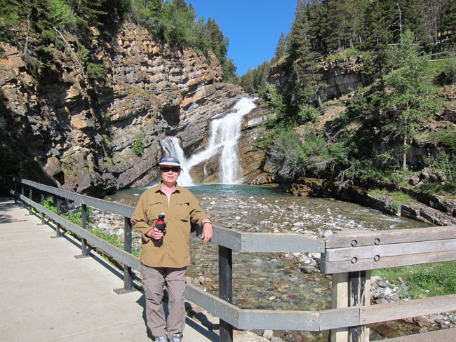
There are a number of striking walks around the area. The third photo shows us at Bow Lake, the source of the Bow River, which runs down the valley though Banff and to Calgary. The Crows Foot Glacier is visible on the mountain behind the lake.
The fourth photo is of Moraine Lake, which may be the prettiest walk we have taken yet.
The crowds are quite large during July and August (which this is) and parking is at a premium. The parking lots for the main tourist attractions and trailheads are full by 11:00AM, so we always get an early start.
To our RV friends. We are in the Lake Louise Trailer CG (part of the NP). It is on a reservation system and has very nice sites in the trees, but yet not too dark so as to allow sun through. The main disadvantage is that the sites are side by side with 2 rigs in one site. Hope for quiet neighbors. It hasn't been a problem for us. Speaking of neighbors, we ran into some friends from home (the Burgners) who are making their way back home after spending the summer in Alaska. Small world.

Tuesday, August 23, 2011

Banff Townsite

On August 18, we arrived in Calgary, Alberta. This was a planned two day stop to do laundry and get provisions for our stay at Banff, N.P. We stayed at a very nice private CG on the west side of Calgary in the town of Cochrane. We were told that it was the nicest private CG in all of Canada. We were backed up to the Bow River which had a nice walking path along the river.
It pays to be in or near a big city. There were plenty of banks where our ATM cards worked, good grocery stores, restaurants, and best of all, a Costco nearby. We did load up.
Sat morning, August 20 we drove about an hour west to enter Banff NP. We sailed right in because we had bought a year pass to all of Canada's NPs. It pays for itself if you stay for at least a week. Knowing that this is the height of the season, we had made reservations for the Tunnel Mt CG. Our reception was much different here than at Waterton NP. The courteous girl at the kiosk assigned us a site but said come back if you don't like it and we will assign you a new spot. One thing that is different in the Canadian NP is you have many choices for different campsites: no hookups, just electricity, full hookups, fire pits, no fire pits. We picked full hookups and luckily the sites were far apart and fairly private. Plus, the CG is fairly close to town. The sites at Tunnel MT 1 are very nice, located in the trees, very private but without hookups. We probably would have picked this CG if we had known ahead of time how nice it was.

The town of Banff is very upscale with many shops and fine restaurants. There is also a well stocked grocery store that we don't often see in NP. There are lots of crowds here, especially on the weekends. The weather has been surprisingly warm, in the 80's, but cooling off at night. In the winter Banff is an upscale ski area since the town is surrounded by majestic mountains and peaks. There are also lots of trails in town and out. Some of the trails are closed because of bear activity. It's the height of berry season and the bears are active.

Thursday, August 18, 2011

Waterton Lakes National Park of Canada

The actual Canadian Rockies portion of this trip started on Monday, August 15, when we crossed into Canada. We took the very lightly traveled road from St Mary Lake to Waterton Lakes National Park of Canada. At the border crossing, we were the only vehicle there and we had a nice visit with the Canadian crossing official. The total mileage on Monday was 46 miles, but we are now on Kilometers, which is driving me nuts.

The first photo is of upper Waterton lake, which is about 6 miles long. The photo was taken from the Prince of Wales Hotel looking south . The town of Waterton Park is in the lower right of the photo right on the lake, with the campground just behind, beneath the mountains. About 1/2 of the lake is in Montana, so you are seeing upper Glacier National Park at the far side of the lake.
The majestic Prince of Wales Hotel sits on a bluff overlooking the lake and the town. It was built in the 1920's and has high wood beamed ceilings with elaborate arches, balconies and turrets. It dominates the skyline. There are fairly heavy winds coming off of the lake, both in town and in the CG. It is said that the hotel creaks and rattles at night because of the winds.
The campground is on a naturally flat plain, about 1 mile in diameter, just adjacent to the town. All options exist at the CG, from no hookups to full. They use an odd system of site assignment at this park. Reservations are possible, but they are not site specific. Our experience with this type of system in the past is that you pick from the available empty sites when you arrive, on a first come-first served basis. You then have the site for the number of nights that you have reserved. The system used at Waterton arbitrarily assigns your site, based on your reservation details (vehicle length, hookups, etc). We had a poor site assigned to us initially, but there were many good sites nearby that were empty when we arrived. We asked to be switched to one of them, but our number of nights didn't match the number of nights reservation for any of those sites. Those other sites were also arbitrarily assigned. So we couldn't move, even though we were here first. We had spotty service from the staff. The first agent, a young man, said "you are stuck with what you got", a very customer friendly attitude. I tried a second time, after the shift change and a young woman tried to move us but was unable to match the same number of nights reserved in one of the other empty campsites to ours. She was very helpful.
But enough complaining! The second photo show our RV with the mountains in the background.
Cameron creek flows through the CG, flowing over Cameron falls just above the CG.
The third photo show Pris in front of the falls, with our newly acquired bear spray. Besides the hike to Cameron Falls, we have taken other hikes while following the instructions of talking loudly and clapping our hands. There are grizzle bear warning signs on the trails, which is a little disconcerting.
We are thoroughly enjoying the town of Waterton Lakes. It's a small town within easy walking distance of the Townsite CG. It has several good restaurants, nice quaint shops, and several coffee and ice cream shops.
As a practical matter, the grocery stores are very limited, there is no bank here, and even though they have ATMs, our cards won't work. We were able to get a store to exchange US money for Canadian dollars but charged us a 5% rate. But we needed money to buy those ice cream cones. All businesses take charge cards, however. No Verizon coverage here either.


Sunday, August 14, 2011

Glacier National Park-East Side


On Thursday Aug 11, we pulled up stakes and headed for the east side of Glacier NP. The shortest route (45 miles) was over the Going-to-the-Sun road. But they limit the size of vehicles on the road to 21 feet long and 10 feet in height and our 51 feet (with towed) by 11 feet didn't quite fit. So we had to go out the west side of the park, pick up US 2 and head east to Browning Mt. As a side note, we have traversed US2 in all three of our trips around the US. It runs from Seattle Wa to Bar Harbor Me, and we have traveled most of it.
From Browning it was about 25 miles to St Mary Campground, our destination , for a total of about 120 miles. This is where the plains meet the mountains, in this case the Rockies. It is more arid on the east side of the mountains and the vegetation is more sparse. The vistas tend to be more sweeping since there is less to obstruct the view.
St Mary lake is beautiful, flanked by the glaciated Rockies. The Going-to-the-Sun road traverses the north side of St Mary Lake and ends in the town of St Mary, some 2 miles further.
The first photo is of Wild Goose Island, in upper St Mary Lake. The photo was taken from the Going-to-the-Sun road, looking west.
The second photo is of the Many Glacier Lodge, overlooking the Swiftwater lake. This lodge was built in the 1920s, as part of the railroad building in the area. This was the most beautiful part of the park, in our opinion. The views from the lodge include the lake with majestic snow covered mountains in the distance. To our non camping friends, this would be the place to stay. To our camping friends, the CG here had sites that were small, close together, and very shady under the trees. Of course, if the weather is hot, the shade would be an advantage. We have only had one really warm day since we have been camping in WA, ID, and Montana and have looked for sites in the sun.
The east side of the NP is not as busy or crowded as the west side. We stayed at the St Mary CG which has beautiful views of the mountains and is more open than the Rising Sun CG. The sites at the Rising Sun CG tended to be smaller, closer together and under the trees and is first come first served. St Mary is on reservation but there were sites available each day at least in the early to mid afternoon.
We drove the first half of the Sun Hwy from Apgar to Logan Pass on the west side and then drove the second half from St Mary up to Jackson Glacier on the east side after our move. The traffic is very congested on the west side with many stops for construction. It's an easy drive up the highway from the east side and only one construction stop. It would be a long 2 hr plus drive, one way, if you drove the road in one day. Many people use the free shuttle bus because parking is a problem. We are at the heighth of the season and we did see some long lines.
One of the most enjoyable things that we did was to take the boat ride on St Mary Lake. The third photo shows Pris on the "dock" to our tour boat, Little Chief, which was built in 1925.
St Mary Lake is a beautiful turquoise color, due to the glacial runoff, is surrounded by majestic mountains and has 5 glaciers feeding into it. Be sure to take the ranger lead hike to Baring and St Mary Falls that can be signed up for ahead of time and be part of the boat ride.


Wednesday, August 10, 2011

Glacier National Park-West Side


We entered Glacier National Park about noon on Monday, August 8, through the west entrance. We had reserved a place at Fish Creek campground, so there was no panic over finding a place at the peak of the tourist season. Bob Filler warned us about that. Fish Creek is the only campground that takes reservations on the west side and there are a few other campgrounds that are first come, first served. One of them, Apgar, is a nicer campground and had a number of available sites the last two days.
The gem at Glacier is the Going-to-the-Sun-Road. Our Fodor's Guide book says" The Going-to-the-Sun-Road is arguably the most beautiful drive in the country". And they get no argument from us. The road is about 32 miles in length, and connects Lake McDonald in the west and Saint Mary Lake in the east. The high point on the road is at Logan Pass, at 6,600 feet. The road is heavily traveled, so we took off early on our first day to explore this high country. There is construction on the upper portions of the road, so we encountered numerous delays. The first photo was taken at one of these stops. Logan Pass is the low point, on the left side of the photo. The road traverses the left side of the mountain and at places has been blasted out of rock and is very steep.
The mountain in the middle of the first photo is shown from Logan Pass visitor center, in Photo 2. There were hundreds of people out on the snow, barely visible in the photo.
On the second day here, we took a hike to Avalanche Lake. The beautiful stream that empties the lake to McDonald lake is shown in photo 3.
Glacier NP has a shuttle system taking people to all the important sites. It's a good way to get around since there are not enough parking spaces. The historic red "jammer" buses offer an alternative means of transportation. Advanced reservations are advised.
We still have our bear spray given to us by Benn Martin, but haven't had to use it, yet. Perhaps we should test it since it hasn't been tested since 2006. There has been a black bear seen in our CG but no grizzlies yet. Glacier NP has the largest grizzly population in the lower 48 states. A hiker was attacked here in the park a few days before we arrived.
Now, let's see, curl up and play dead with a grizzly and stand tall and be aggressive with a mountain lion and black bear. Hope I can keep that straight.

Sunday, August 07, 2011

Heading East to Glacier NP


We left North Cascades on Wednesday, the 3rd, and headed east on Washington 20. It was a pretty drive and with almost no traffic. We had planned on taking one week to cover the 600 miles east to Glacier National Park and to stay at some new camping areas.
The first one on our list was Steam Boat Rock State Park, in eastern Washington. It is just down the lake from the mighty Grand Coulee dam. We came in from the northwest and the dam is awfully impressive from that direction. They claim that it is the largest on the Columbia series of dams. The first photo shows Steamboat Rock from our campsite, about 1000 feet high. While the park is pretty, there was no lack of young kids/families at this water oriented park. There must have been 50 kids on our little loop alone. So we said farewell after one night and continued our eastward trek.
The next place on our list was Coeur D'Alene, Idaho, that is located on a lake of the same name. We stayed two nights in a commercial RV park east of town. The annual street fair & Art show was starting when we arrived and the town was packed. We took a tour of the lake that was as informative as it was pretty. The second photo was taken on that tour and is of the Coeur D'Alene Resort. It is one of the nicer resorts there. The suite on the top (18th) floor is said to have a swimming pool cantilevered out from the building, with a glass bottom! Must be quite a view while swimming laps.
Our last stop before getting to Glacier was the town of Missoula, Montana. We stayed here two years ago on our Lewis & Clark trip and liked the town and RV park (Jim & Mary's). The third photo shows Pris, in downtown Missoula, with the University of Montana across the river.
The fruits and vegetables continue to amaze (at least one of us). The raspberries are as large as your thumbs and as sweet as can be. Blueberries are also large and delicious. Huckleberries are everywhere for the picking. Farmer's Markets are loaded with everything you could ask for.
It's been awhile since we have RVed in the summer because of the crowds, but we wanted to beat any hint of snow in the Canadian Rockies. We are finding that reservations in the campgrounds, both private and public, are recommended because of this being the busy season. People are out and on the road.

Thursday, August 04, 2011

North Cascades National Park


After the family get together last weekend, we headed for the woods. The North Cascades National Park is about 120 miles to the north east of Seattle, up the Skagit river valley. At the head of the valley, the Seattle Electric Company built some 3 dams for hydroelectric power generation. The first photo shows one of the lakes behind the upper dam. The canyon is getting very steep at this point. The national park contains over 1/2 of all the glaciers in the lower 48 states, although we didn't count all of them.
Being on the western side of the Cascades, there is plenty of rainfall. The second photo was taken in our campground, with our RV in the background. Notice the ferns and moss! This is typical in the national park.